Historic Water Courses
Interest in the many hidden streams, which had formerly flowed beneath the streets of the Redington Frognal area, was prompted by conversations with the late Dr Stephen Myers, water engineer and author of Walking on Water (2011).
To learn more, Redington Frognal Neighbourhood Forum commissioned Arup to undertake a desk-based mapping assessment. This research was to be a key element of the evidence base for a Neighbourhood Plan policy on underground development.
The streams had formed the headwaters of the River Westbourne but, during the Victorian era, they were combined into sewers.
The presence of underground rivers or other bodies of water is often indicated by soggy ground, poplar and willow trees. RedFrog became interested in daylighting underground rivers following a meeting with water engineer Dr. Stephen Myers, in May 2015. At the end of 2016 Arup was commissioned to map underground rivers for the neighbourhood plan evidence base.
The Arup map of RedFrog underground rivers indicates the presence of many historic rivers, such as the Westbourne, East Westbourne, Cannon, unnamed rivers, springs, wells and ponds. As many as five water courses can be found within a space of 800 yards. While these have mostly been absorbed into sewers, clean water runs between Branch Hill and Redington Gardens, where the stream can be heard. Mostly, however, the streams have become degraded, devalued, and discarded – interred in underground culverts, out of sight, out of mind.
Sub Surface Water Features in the Redington Frognal Area
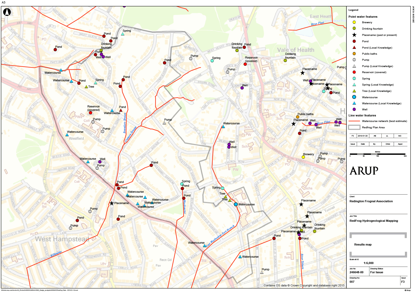
Source: Arup / RedFrog https://www.redfrogforum.org/underground-rivers/
This map is taken from the Arup Red Frog Sub-surface Water Features Mapping Report. More information on the flow of underground rivers is also available on the RedFrog Forum website.
The Arup map of RedFrog underground rivers indicates the presence of many historic rivers, such as the Westbourne, East Westbourne, Cannon, Boundary Stream, unnamed rivers, springs, wells and ponds. Of these, one clean stretch of the underground Westbourne is known to remain: clean water runs between Branch Hill and Redington Gardens, where the stream can be heard.
The lost rivers are now enclosed in drains running down the middle of the road. Their locations are freely available to insurers via the BGS 1920s map and the Thames Water sewers plan.
Further reading:
Time Out featured an article on How our cities’ lost rivers are being revived, by Julia Webster Ayuso in 2022.
Time Out featured an article on 11 lost rivers in London you should know about, written by Robert Lordan in 2016.
Surface water: The biggest flood risk of all
Details of the speech made by Sir James Bevan KCMG, Chief Executive, Environment Agency 17.10.18 outlining why surface water flooding is such a real and growing risk is available here: Surface water-The biggest flood risk of all-GOV.UK
The Redington Frognal area lies within a Flood Risk Zone and Critical Drainage Area and Camden is designated at “lead local flood authority”.
Surface water flooding last occurred here in 2002 – see photo of Lymington Road below, take from page 24 of “Managing flood risk in Camden: The London Borough of Camden flood risk management strategy” at the link below:
https://www.camden.gov.uk/documents/20142/1458280/Camden_Flood_Risk_Management_Strategy.pdf/9e739029-02e5-59c7-e9a4-64d3622f2475?version=1.0

The cause of the 2002 flooding was accepted to have been overwhelmed sewers and drainage systems. Further information is available in the attached Arup report:
https://beta.camden.gov.uk/documents/20142/2247044/GHH+study.pdf/12f5a776-e382-21fe-8dbd-04ea4db575b3
And there is more information here:
https://www.my5.tv/the-great-flood-of-london/season-1/sinking-cities-london
Daylighting Lost Rivers of London
A video presentation by Dr Adam Broadhead of ARUP available on YouTube
Walking the Westbourne
As a further stage, it is proposed to mark the historic route of the lost River Westbourne, which has its origins at Branch Hill. The river flowed through Kilburn and the Serpentine, beneath Knightsbridge and into the Thames by Chelsea Hospital, but has long been absorbed into London’s sewer network, as seen on the exhibition boards.
In November 2025, wooden bollards incorporating a QR code linking to this website were installed. The Walking the Westbourne geological walking trail will be uploaded here very shortly.
Read more about the Westbourne on our page the Lost River Westbourne here.