Hydrogeology of Redington Frognal
The Redington Frognal area is naturally very wet, with many underground streams, due to groundwater that has reached the surface and since been culverted and buried1.
The abundance of water is confirmed by the 1866 OS map of the area, which shows many pumps (P) and wells (W) and A Dictionary of London Place-Names by AD Mills, which records,
“ffrognal 1372, Frogenhall 1542, Frognall 1795, that is ‘nook of land frequented by frogs”2.
This is consistent with the many ponds which formerly characterised the area. Other evidence of the historically wet area includes:
- the former pond at Branch Hill;
- the covered Kidderpore Reservoir was not designed to capture local springs, as with early reservoir ponds on Hampstead Heath. Instead the reservoir was constructed in 1867 to store treated water extracted from the Thames at Hampton, and pumped by steam engine to high ground on Hampstead Heath for gravity distribution to nearby homes
- Blacket’s Well forming an early border marker near Platt’s Lane on Childs Hill
- other numerous wells, springs and buried streams known in basements and gardens of households
- present or past poplar and willow trees (often located in wet riparian soils)
- various books on the lost rivers of London (Nicholas Barton, Paul Talling, Tom Bolton and Stephen Myers).
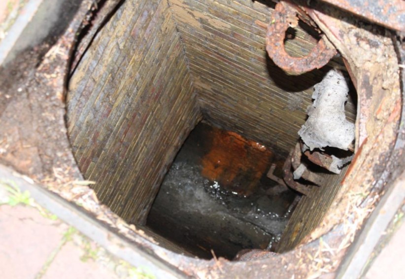
The underground River Westbourne (also known as the Cannon), emerges downstream to form the Serpentine in Hyde Park. The photo below shows the culverted Westbourne, which emerges downstream to form the Serpentine in Hyde Park.
Lost River Westbourne, flowing in a sewer beneath Redington Gardens
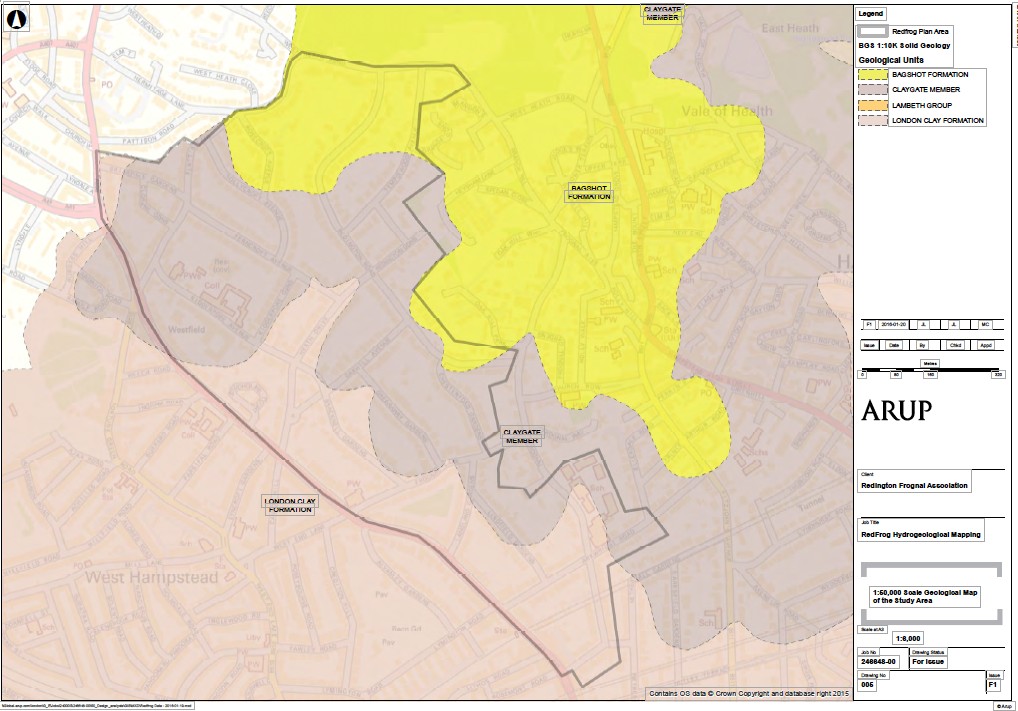
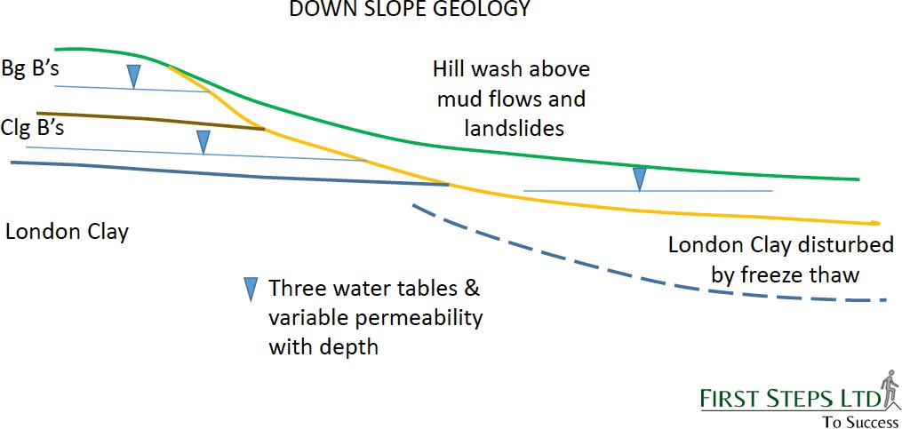
The ground beneath Redington Frognal is a complex layering of Bagshot Sands, Claygate Member and band D of the London Clay Formation. The top two layers have a high silt and sandy component rendering them susceptible to high water conductivity, as well as being potentially less stable: even band D of the London Clay Formation, while less permeable, still has a variable but significant silt content with a degree of erodibility, and can contain water under pressure in sand partings.
Ground types in the RedFrog Area

Source: Arup Community Mapping of the Lost Streams of London presentation to the 18th RRC Annual Network Conference, Brighton 4-5th April 2017 by Adam Broadhead, Michael Chendorain and Jon Leech
From top to bottom, the differing ground types in the area are:
Made Ground (usually containing a small percentage of anthropogenic debris – brick, clinker, ceramic, wood etc.). This can be many metres thick and be stratified to form layers semi-parallel to ground level and containing a mixture of thin seams and lenses of variable permeability.
- The more permeable seams, rich in silt and sand, act as micro aquifers in which ground water travels at a greater rate than the more clay rich material which bounds them.
■ Measuring the water level within each seam requires special
techniques - The ground water carried in these layers is derived from the infiltration of rainfall augmented by discharges from soakaways and leaky piped water.
Bagshot Formation (informally Bagshot beds or Bagshot sand). This is an iron- rich sand with discernible layering of varying grain size and with occasional pebble layers and is permeable. Infiltration from rainfall produces a natural reservoir that sits at the top of Hampstead Heath. The southern boundary of this reservoir extends as far as Redington
Road. =
Claygate Member of the London Clay Formation (a silty version of London Clay with some partings of fine sand). Claygate Member is defined as a secondary aquifer Claygate Beds. These are a deposit which can be mapped as distinctly different from the London Clay strata below, and include:
- Claygate Beds Unit D of 30 m to 45 m thick
- Claygate Beds Unit E. This is more permeable.
• The boundary between the Bagshot beds and Claygate beds and differing permeability of these layers means the discharge of ground water through the Bagshot beds is greater than that through the Claygate beds3.
Impermeable London Clay Formation (at the bottom) is generally found at a depth of more than 8 metres in the Redington Frognal area, but will vary considerably according to the location on the slope. [The majority of Redington Road is underlain by London Clay and it will only be the depth of Made Ground and/or Head that overlies it.]
Head Propensity (Head). Where this exists, it is a relatively recent covering of silt- clay deposits, largely derived from a mix of Bagshot sand, Claygate beds with some London Clay Formation that have moved downslope by solifluction (mass movement under periglacial conditions).
Arup Redington Frognal Hydrogeological Mapping
 Source: Arup Red Frog Sub-Surface Water Features Mapping, April 2016
Influence of Geology on Groundwater Flow
Groundwater is a global resource of fundamental significance. Seventy-five per cent of the world’s water supply is provided from groundwater. The sand in the Claygate Member and the Bagshot Formation makes them relatively permeable. The water within these strata is recharged at the surface from precipitation which, owing to the relatively high porosity, forms a local aquifer.
The amount of water that is available to enter groundwater in a region is influenced by climate, the slope of the land, the type of rock at the surface, the vegetation cover, land use in the area, and water retention (the amount of water that remains in the ground).
At the junctions of the Bagshot Formation with the Claygate Member and the Claygate Member with the London Clay, spring-lines form and groundwater flows into various drainage channels throughout the area, forming tributaries and then rivers. Periods of abnormally high rainfall can result in groundwater flooding of basements and the emergence of groundwater at the ground surface, causing damage to property and infrastructure. The North London Strategic Flood Risk Assessment4 identified several areas that have experienced surface water flooding when existing water infrastructure has not been able to cope with surface and foul water during heavy rain.
Geology and Soils in the London Borough of Camden
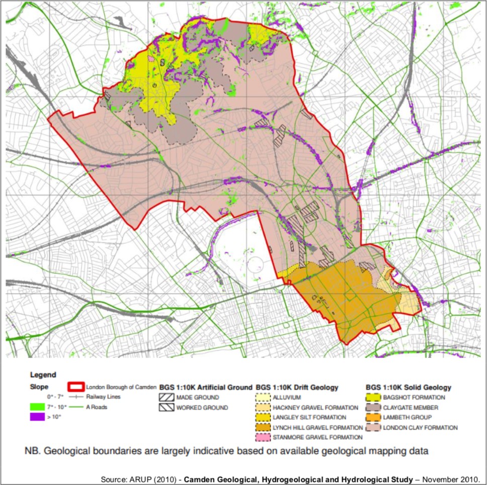 Note: it has been advised that the key is incorrect: Lambeth Group is older than London Clay and should be shown at the bottom.
How the springs relate to the geology
The geology, as described in the sections above, gives rise to a spring source at the surface where the permeable geology meets impermeable clays below. The waters for springs accumulate in the porous sands of the Bagshot Beds on the upper parts of the Heath. The Bagshot Beds absorb water like a sponge and allow rainfall to pass downward until it reaches underlying clay beds, when the groundwater flows laterally to emerge on the hill slopes as springs, which are visible in winter and early spring. This spring line circulates the Heath at approximately the 130 m contour line, but variations in the composition of the soils will result in springs being located within a range of this elevation.
Rainwater also drains into the channels, further developing the shapes of tributary watercourses. Further downhill, the volume of water flowing into the rivers increases, as the contributing catchment area increases and as tributaries merge. The flow in these groundwater-fed rivers fluctuates with rainfall, but has a relatively steady baseflow component from the springs. Baseflow can fluctuate seasonally in response to weather patterns, longer term climatic changes, and may also be influenced by humans through pumping and other activities.
The rivers in the vicinity of Hampstead Heath, whether currently visible at the surface or concealed below ground, are directly related to the area’s hydrogeology. These rivers were once a vital source of water for early settlers. When emerging from the ground, the water carries with it the properties of the sand through which it has passed, and the springs of Hampstead have a long history of providing supplies of water for the rest of London. Conduits were built to channel water from the springs along the heath to the centre of the city.
Shepherd’s Well, whose flow was thought to be nearly as pure as distilled water, is the source of the River Tyburn.
Shepherd’s Well in 1820
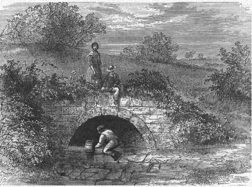
Source: The Underground Map http://www.theundergroundmap.com/image.html?id=2961
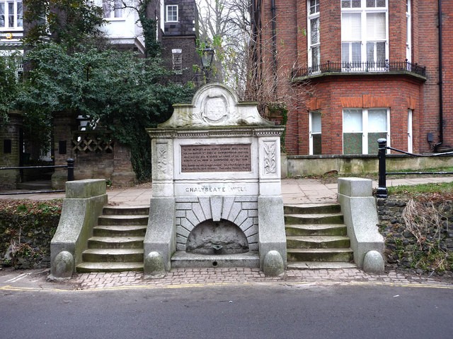
The area has a number of chalybeate springs containing iron salts, some of which feed the River Fleet. In previous centuries these waters were considered to have medicinal qualities. The high iron content gave rise to the belief that the water had medicinal properties and Hampstead developed as a pleasure resort, catering for Londoners who came to take the waters. The water was even bottled and sold.
Chalybeate Well in Well Walk
As the rivers became polluted, were covered and culverted and incorporated into the sewer network and buried by the development of London. A map of the sewer network is in RedFrog is available from Thames Water.
Culverted rivers are known as London’s historic or lost rivers and include the River Westbourne (also known as the Cannon), the Fleet and the Tyburn, which all flow directly into the Thames. However, some fresh water still flows freely beneath the ground, throughout the area.
Groundwater in the Redington Frognal area
In 2015, Redington Frognal Neighbourhood Forum commissioned Arup to undertake a high-level desk-based mapping assessment of lost streams and springs. The purpose of the work was to provide an independent assessment of whether there were any water features that have been lost from the surface in the area of interest and provide an indication of where they may be.
Arup Redington Frognal Hydrogeological Mapping – Historic Rivers
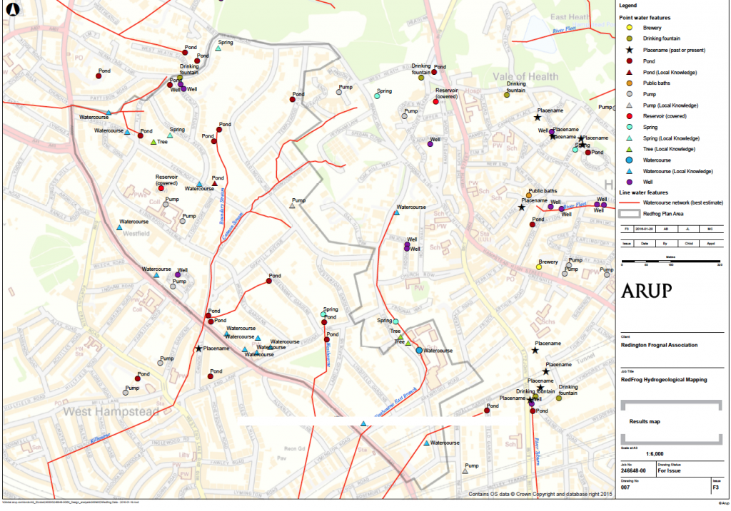 Source: Arup Red Frog Sub-Surface Water Features Mapping, April 2016

The whole RedFrog area is underlain with water and aquifers, which may be sited at less than one metre below ground. Major spring lines occur at the junctions of:
- Bagshot Sands and Claygate Beds
- Claygate Beds and London Clay Formation (band D), where there are springs and seeps and (eg up the slope from the [man-made] Highgate Ponds and Meg’s Pond (created by Meg from a seep beside some poplar trees).
The waters for the springs accumulate in the porous sands of the Bagshot Beds (which form the upper parts of the Heath). The Bagshot Beds absorb water like a sponge and allow rainfall to pass downward until it reaches underlying clay beds, at which point, groundwater flows laterally to emerge on the hill slopes as visible springs.
In winter and early spring, water can flow freely from the sands, and springs will be quite obvious on the hill slopes of the Heath. Plant life provides the best clues to the springs. Areas with yellow irises and buttercups identify ground that is permanently wet.5
In the Redington Frognal area, spring-lines are found at locations including:
- along Redington Road. This means that there is water everywhere at ground and below ground, inthe form of seeps, ponds, tributaries, springs and culverted tributaries, i.e sewers
- parallel and immediately south of Lindfield Gardens.
Head wash and silt washout occur throughout, e.g. in Arkwright Road, and presentconstraints to basement development.
Ground types and subsidence risk
Different types of ground carry different risks of subsidence. The water flow through Made Ground and Head zones is less predictable Head zones are more soluble than other ground types. Head zones, which are more soluble than other ground types, have a particularly high riskof landslide and known groundwater.
The junctions between the Bagshot Sand / Claygate Beds and Claygate Beds / London Clay are also particularly susceptible. An example of the susceptibility to subsidence in the vicinity of the junction between Bagshot Sand and Claygate Beds is seen from the cracking visible inHampstead Parish Church in Church Row.
London Clay can be problematical on a slope as it swells in winter when it is wet and shrinks in summer, particularly during droughts. Even rainwater falling directly onto London Clay can havea shrink/swell effect leading to potential subsidence.
Developments along the spring lines can be particularly problematic.
Material based on:
Dr. Michael de Freitas (33 Redington Road tree felling objection),
Dr. Vicki Harding, Heath and Hampstead Society (Camden Arts Centre tree felling objection)
Diana Clements, chapter 3 of The Geology of London
Arup Redington Frognal Sub Surface Water Feature Mapping report, April 2016 UCL Geology onHampstead Heath https://www.ucl.ac.uk/earth- sciences/impact/public-engagement/londons-geology/londons-geology- fieldwork/hampstead-heath/geology-hampstead
1 http://www.redfrogforum.org/wp-content/uploads/2019/11/77-Arup-Red-Frog-Sub-surface-Water-Features- Mapping.pdf
2 http://edithsstreets.blogspot.com/2020/04/hampstead.html https://hidden-london.com/gazetteer/frognal/
https://www.nytimes.com/1998/03/01/magazine/hampstead-high.html
3 for a given gradient of ground water levels
4 Mouchel, 2008, North London Strategic Flood Risk Assessment
5 https://www.ucl.ac.uk/earth-sciences/impact/public-engagement/londons- geology/londons-geology-fieldwork/hampstead-heath/geology-hampstead
A pdf file of the content above is available here:
http://www.redfrogassociation.org/wp-content/uploads/2020/09/Hydrogeology.pdf